What Are Cumulus Clouds? A Complete Guide for Weather Watchers and Photographers
Cumulus clouds are the classic fluffy white clouds seen on sunny days. Discover how they form, what they reveal about the weather, and why photographers love them.
Cumulus clouds are among the most familiar and recognisable clouds in the sky. With their bright white appearance and distinctive cotton-like shapes, they are often the clouds children draw in pictures and the clouds most people associate with fair weather.
However, cumulus clouds are more than just beautiful features of a summer sky. They are an important part of Earth's weather system and can provide valuable clues about atmospheric conditions.
In this guide, we'll explore how cumulus clouds form, what they tell us about the weather, and why they are a favourite subject for weather photographers.
What Are Cumulus Clouds?
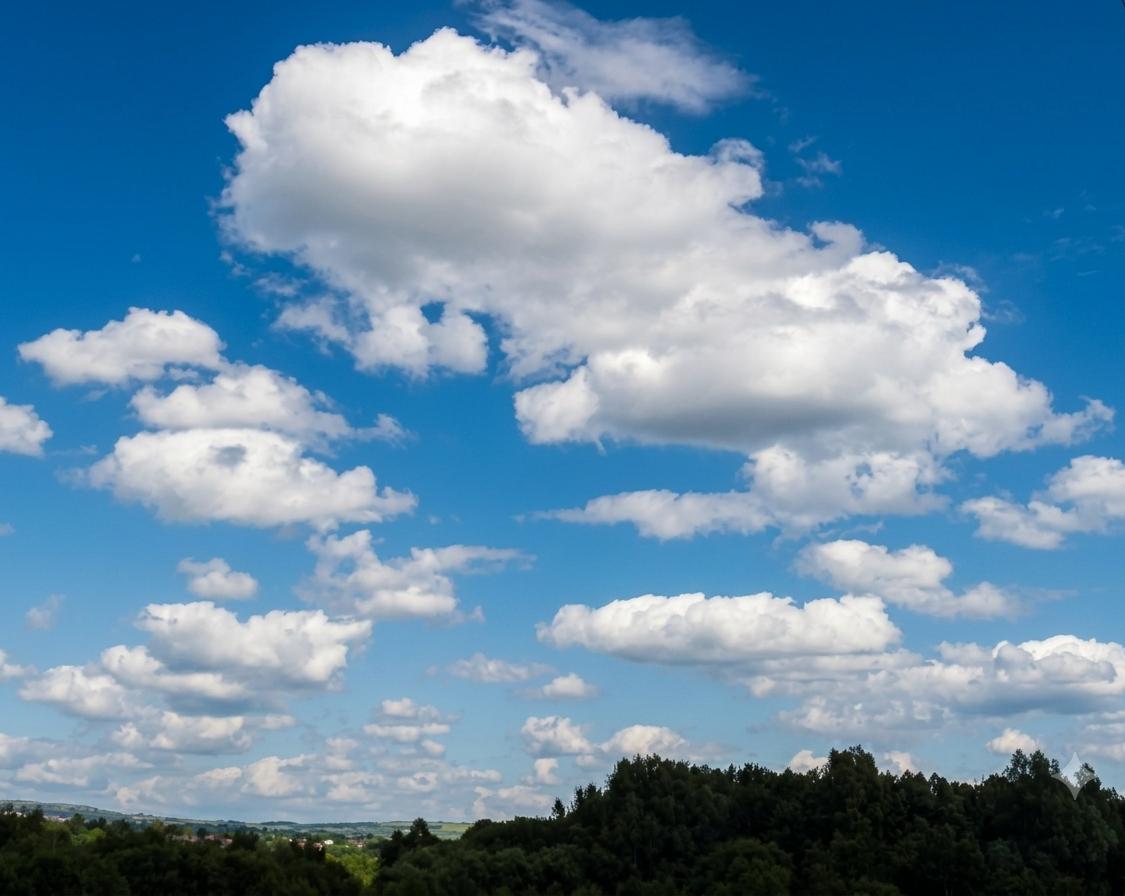
Cumulus clouds are low-level clouds with flat bases and rounded, puffy tops that often resemble heaps of cotton wool.
The name "cumulus" comes from the Latin word for "heap" or "pile," which perfectly describes their appearance.
They typically develop during the daytime when the Sun heats the Earth's surface. Warm air rises, cools as it climbs, and water vapour condenses into tiny water droplets, forming clouds.
Most cumulus clouds have well-defined edges and a brilliant white colour when illuminated by sunlight.
How Do Cumulus Clouds Form?
Cumulus clouds form through a process known as convection.
As sunlight warms the ground, pockets of warm air begin to rise. These rising bubbles of air, known as thermals, cool as they ascend through the atmosphere.
When the air cools to its dew point, water vapour condenses into tiny droplets, creating a cloud.
The flat base of a cumulus cloud marks the altitude where condensation begins. The rounded upper portions continue growing as warm air rises through the cloud.
On a typical fair-weather day, thousands of small cumulus clouds may develop across the landscape during the afternoon before gradually dissipating toward sunset.
What Weather Do Cumulus Clouds Indicate?
In most situations, cumulus clouds are associated with fair weather.
Small, scattered cumulus clouds often indicate:
- Stable atmospheric conditions
- Light winds
- Good visibility
- Little chance of significant rainfall
For this reason, they are sometimes called fair-weather cumulus.
However, not all cumulus clouds remain small.
If the atmosphere is unstable and warm air continues rising, cumulus clouds can grow vertically into much larger clouds capable of producing showers, thunderstorms and severe weather.
Types of Cumulus Clouds
Meteorologists recognise several forms of cumulus clouds.
Cumulus Humilis
These are the classic fair-weather cumulus clouds.
They are wider than they are tall and generally indicate stable conditions.
Cumulus humilis often decorate blue skies on pleasant spring and summer afternoons.
Cumulus Mediocris
These clouds show moderate vertical development.
They are taller than cumulus humilis and suggest that atmospheric instability is increasing.
Cumulus Congestus
Sometimes called towering cumulus, these clouds can grow dramatically upward and resemble giant cauliflower heads.
Cumulus congestus often produce brief showers and may continue developing into thunderstorms.
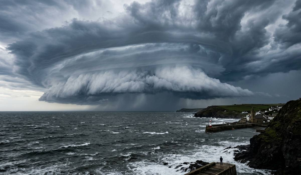
Can Cumulus Clouds Become Thunderstorms?
Yes.
Under the right conditions, cumulus clouds can evolve into towering cumulonimbus clouds.
This process occurs when:
- Warm, moist air continues rising.
- Atmospheric instability is present.
- Winds and temperatures support vertical cloud growth.
As the cloud grows taller, it may begin producing rain, lightning, thunder, hail and strong winds.
Many severe thunderstorms begin their life cycle as ordinary-looking cumulus clouds.
Why Do Cumulus Clouds Have Flat Bases?
One of the defining characteristics of cumulus clouds is their remarkably flat base.
This occurs because condensation begins at a specific altitude where rising air cools enough for water vapour to condense.
Since the surrounding air reaches this temperature at approximately the same height, neighbouring cumulus clouds often develop bases at similar levels.
Photographers often notice this striking alignment across the sky.
Are Cumulus Clouds Good for Photography?
Absolutely.
Cumulus clouds are among the most photogenic cloud types because they provide:
- Strong contrast against blue skies
- Dramatic textures and shadows
- Depth and scale in landscapes
- Constantly changing shapes
Morning and late-afternoon light can add extra dimension to cumulus clouds, creating spectacular opportunities for landscape and weather photography.
Towering cumulus clouds are particularly popular subjects because of their impressive vertical structure.
Frequently Asked Questions
How high are cumulus clouds?
Cumulus clouds typically form at low levels, often between 500 and 2,000 metres (1,500 to 6,500 feet), although this varies depending on local atmospheric conditions.
Do cumulus clouds produce rain?
Most fair-weather cumulus clouds do not produce rain.
However, larger cumulus congestus clouds can generate showers and may eventually develop into thunderstorms.
What's the difference between cumulus and cumulonimbus clouds?
Cumulus clouds are generally smaller and associated with fair weather.
Cumulonimbus clouds are much taller, extending through multiple layers of the atmosphere and producing thunderstorms, lightning, heavy rain and sometimes hail.
Are cumulus clouds more common in summer?
They are often more noticeable during spring and summer because stronger solar heating creates the rising air currents needed for their development.
The Clouds We See Most Often
Cumulus clouds are one of the most common cloud types on Earth and are often the first sign that the atmosphere is actively mixing and evolving.
Most remain harmless fair-weather clouds, drifting across the sky on warm afternoons. Yet under the right conditions, they can grow into towering storm clouds capable of producing dramatic weather.
Whether you're a weather enthusiast, photographer or simply someone who enjoys looking up, understanding cumulus clouds is an excellent first step toward recognising the atmosphere's daily patterns.
Explore more cloud guides:
- What Are Altocumulus Clouds?
- What Are Cirrus Clouds?
- What Are Mammatus Clouds?
- Shelf Cloud vs Wall Cloud
- Why Are Storm Clouds Green?
Have you photographed beautiful fair-weather cumulus clouds or towering storm-building clouds? Share your images with the StormHour community and help others learn to appreciate the skies above them.
📩 Join StormHour (Free)
Get more from your weather photography.
Join StormHour for free and get instant access to:
- Photography prompts
- Camera settings cheat sheets
- Member-only downloads
- Future guides and resources
Already a member? Check your dashboard for the latest downloads.