Why Are Storm Clouds Green?
Discover why storm clouds sometimes turn green, what causes the unusual colour, and whether green skies are linked to severe weather or tornadoes.

Dark, green-tinted storm clouds are often associated with severe thunderstorms, hail and intense rainfall. The unusual colour develops when sunlight passes through deep storm clouds containing large amounts of water and ice, particularly late in the day when the angle of the sun is lower.
For many weather observers, a green sky is one of the most striking and unsettling signs that a storm may be intensifying.
What Causes Storm Clouds to Look Green?
The green appearance is caused by the way sunlight interacts with moisture, ice and the depth of a thunderstorm cloud.
During the late afternoon or early evening, sunlight becomes warmer and more reddish as it travels lower across the horizon. When this reddish light passes into a towering thunderstorm filled with water droplets and hail, the blue wavelengths can scatter and combine with the red light to create a greenish hue beneath the storm.
The effect is usually strongest when:
- the storm is extremely tall
- the cloud contains large amounts of water or hail
- the sun is relatively low in the sky
- darker storm bases block direct sunlight
The colour itself does not cause severe weather, but it often appears in storms that are already very intense.
Are Green Storm Clouds Dangerous?
Not always but they can be a warning sign.
Green skies are commonly associated with:
- severe thunderstorms
- large hail
- torrential rain
- powerful downdrafts
- occasionally tornado-producing storms
Many hailstorms produce a green tint because hail-filled clouds are exceptionally dense and deep. However, not every green storm becomes dangerous, and not every dangerous storm turns green.
The colour should be treated as a sign to monitor conditions carefully rather than as proof that a tornado is forming.
Why Does the Sky Sometimes Turn Green Before a Storm?
In some cases, the entire sky may appear greenish before heavy rain or hail arrives.
This often happens when:
- sunlight illuminates the storm from behind,
- the cloud becomes extremely moisture-laden,
- and darker cloud layers block normal daylight.
The human eye is especially sensitive to green wavelengths, making the effect appear more dramatic than it physically is.
For storm observers, the atmosphere can suddenly feel unusually dark, still and heavy at the same time the sky takes on its green tint.
Do Tornadoes Cause Green Skies?
This is one of the most common weather myths.
Tornadoes themselves do not create green skies.
However, some supercell thunderstorms capable of producing tornadoes may also create the conditions needed for green colouring:
- deep cloud structures
- heavy precipitation
- large hail cores
- low evening sunlight
This overlap is why green skies became historically linked with tornado folklore.
A green sky should never be interpreted as a guaranteed tornado warning, but it can indicate a storm strong enough to deserve attention.
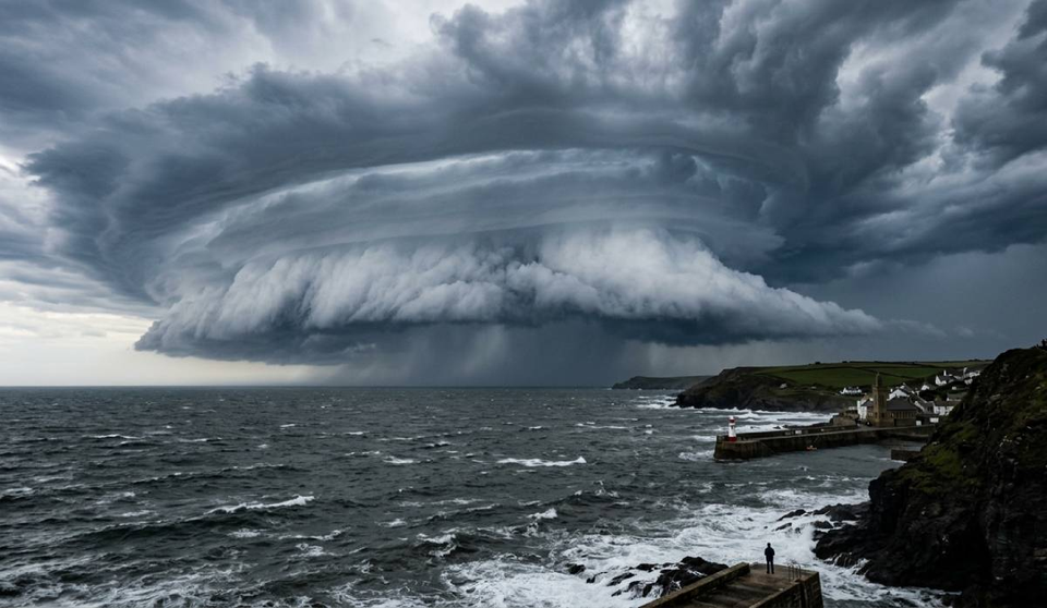
Why Are Some Storm Clouds Almost Black?
Storm clouds appear darker as they become thicker and denser.
In very deep cumulonimbus clouds, sunlight struggles to penetrate through the cloud base. This creates the dramatic charcoal or black appearance often seen before severe rainfall.
Green colouring sometimes develops alongside these darker regions where filtered sunlight still reaches parts of the storm.
Can Green Clouds Happen Without Severe Weather?
Occasionally, yes.
Certain atmospheric conditions can briefly create greenish tones without severe storms, especially near sunset when light interacts with layered clouds and rain shafts.
But in most cases, distinctly green thunderstorm skies are linked to strong convective storms containing significant moisture or hail.
Photographing Green Storm Clouds
Green storm skies can produce extraordinary photographs, particularly when combined with:
- shelf clouds
- lightning
- rain shafts
- dramatic cloud texture
A few useful photography tips:
- avoid oversaturating colours in editing
- expose carefully for the brighter horizon
- use wide-angle lenses to capture storm structure
- prioritise safety over positioning
Some of the most atmospheric storm photographs happen just before heavy rain arrives, when the sky still contains directional light beneath the storm base.
Related Weather Phenomena
Green storm clouds are often associated with:
- shelf clouds
- mammatus clouds
- hail shafts
- severe thunderstorms
- virga
- distant lightning activity
You may also notice rapid temperature drops, gusty winds and an unusual stillness in the atmosphere shortly before the storm arrives.
Continue Reading
You might also enjoy:
📩 Join StormHour (Free)
Get more from your weather photography.
Join StormHour for free and get instant access to:
- Photography prompts
- Camera settings cheat sheets
- Member-only downloads
- Future guides and resources
Already a member? Check your dashboard for the latest downloads.
Your turn
Have you seen this cloud type recently—or tried photographing it?
Leave a comment below or share your experience. Every observation helps build a better understanding of the sky.