Shelf Cloud vs Wall Cloud: How to Tell the Difference
Shelf clouds and wall clouds are both dramatic storm features, but they form in very different parts of a thunderstorm and can indicate very different weather conditions.
Few storm features create as much confusion as shelf clouds and wall clouds. Both can appear dark, dramatic, and intimidating beneath thunderstorms, yet they form in very different parts of a storm and can signal very different weather conditions.
For weather photographers and storm observers, learning to distinguish between the two is an important step in understanding thunderstorm structure. A shelf cloud often marks the leading edge of powerful outflow winds, while a wall cloud can indicate a strong rotating updraft and, in some cases, the potential for tornado development.
Understanding the difference changes the way you watch storms. Once you recognise the visual clues, thunderstorms begin to reveal the story of the atmosphere unfolding above you.
Shelf Cloud vs Wall Cloud: Quick Comparison
Feature | Shelf Cloud | Wall Cloud |
Location | Leading edge of storm | Beneath the updraft region |
Shape | Wide, horizontal wedge | Localized lowering |
Formation | Cool outflow air | Rising inflow air |
Associated Weather | Gusty winds, heavy rain | Possible rotation, tornado potential |
Tornado Risk | Usually low | Sometimes significant |
Appearance | Attached to storm front | Isolated lowering beneath rain-free base |
What Is a Shelf Cloud?
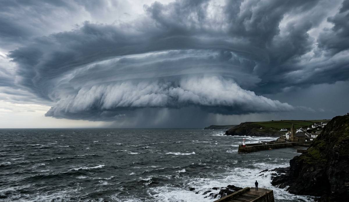
A shelf cloud is a low, horizontal cloud attached to the leading edge of a thunderstorm’s gust front. It forms when cool air descending from the storm spreads outward across the ground, forcing warm, moist air to rise rapidly ahead of it.
As this warm air rises and condenses, a dramatic wedge-shaped cloud can develop along the storm’s leading edge.
Shelf clouds are often associated with:
- sudden temperature drops
- strong straight-line winds
- heavy rainfall
- blowing dust
- rapidly changing skies
They can stretch for many miles and often appear as enormous layered structures moving toward the observer.
For photographers, shelf clouds are among the most visually striking storm features. Their sweeping structure and textured layers can create dramatic atmospheric scenes, especially during late afternoon or sunset light.
What Is a Wall Cloud?
A wall cloud is a localized lowering beneath the rain-free base of a thunderstorm. Unlike a shelf cloud, which forms from cool outflow air, a wall cloud develops beneath a storm’s updraft where warm, moist air is being pulled upward into the thunderstorm.
Wall clouds are typically smaller and more isolated than shelf clouds. They often appear beneath the southwestern portion of a supercell thunderstorm in the Northern Hemisphere.
Some wall clouds rotate, and rotating wall clouds can occasionally produce tornadoes.
Important signs sometimes associated with wall clouds include:
- persistent lowering beneath the storm base
- visible rotation
- rising cloud motion
- inflow bands feeding into the storm
Not every wall cloud produces a tornado, and many never rotate strongly. However, they deserve careful observation because they can indicate an organised and potentially severe storm structure.
Why Shelf Clouds and Wall Clouds Get Confused
Both features can appear dark, low, and dramatic beneath thunderstorms, especially to casual observers viewing storms from a distance.
The confusion often comes from the fact that:
- both are associated with severe weather
- both can appear turbulent
- both form beneath cumulonimbus clouds
- photographs may lack perspective or storm context
However, their position relative to the storm is usually the clearest clue.
A shelf cloud forms along the storm’s leading edge, often stretching horizontally across the sky like a giant wedge or arc.
A wall cloud forms beneath the storm’s updraft region and usually appears as a more compact lowering beneath the base of the storm.
Which Is More Dangerous?
Shelf clouds can produce dangerous straight-line winds, sudden gusts, heavy rain, and rapidly changing conditions. While they may look ominous, they are not usually associated with tornado formation.
Wall clouds can be more significant from a severe weather perspective because they sometimes indicate strong storm rotation. A rotating wall cloud can precede tornado development, particularly within supercell thunderstorms.
That said, appearance alone should never be used to judge storm safety. Storms are complex systems, and conditions can change rapidly.
Whenever severe weather approaches:
- monitor official forecasts and warnings
- maintain safe shelter options
- avoid exposed areas
- never position yourself in the direct path of a storm
How to Identify a Shelf Cloud in the Field
Shelf clouds often have several recognizable characteristics:
- attached to the storm’s leading edge
- broad and horizontal appearance
- layered or “stacked” texture
- advancing rapidly toward the observer
- strong winds arriving shortly afterward
Many shelf clouds produce dramatic visual transitions as sunlight disappears beneath the approaching storm.
Photographers frequently capture shelf clouds over open plains, coastlines, and desert landscapes where the storm structure is fully visible.
How to Identify a Wall Cloud in the Field
Wall clouds are usually more isolated and concentrated beneath the storm base.
Key features include:
- localized lowering beneath the rain-free base
- visible upward cloud motion
- occasional rotation
- nearby inflow into the storm
- separation from the storm’s leading edge
Wall clouds are often partially obscured by rain curtains or low visibility, making careful observation important.
Photographing Shelf Clouds and Wall Clouds
Both storm features offer incredible photographic opportunities, but safety should always come first.
Photographing Shelf Clouds
Shelf clouds are often best captured using:
- wide-angle lenses
- foreground elements for scale
- panoramic compositions
- fast-moving time-lapse sequences
Because they can span huge portions of the sky, open landscapes work especially well.
Photographing Wall Clouds
Wall clouds are usually more compact subjects requiring careful framing and constant awareness of storm movement.
Useful approaches include:
- documenting storm evolution over time
- including rain-free bases and inflow structure
- maintaining safe distance from severe storms
- using radar and weather data for situational awareness
Storm photography should always remain secondary to personal safety.
Final Thoughts
Shelf clouds and wall clouds may appear similar at first glance, but they represent very different processes within a thunderstorm.
A shelf cloud marks the powerful outward surge of cool air spreading away from a storm. A wall cloud reveals the focused upward motion feeding energy into the storm itself.
Learning to recognise these features adds another layer of understanding to storm watching and weather photography. Over time, the atmosphere becomes easier to read. The shape of the clouds, the movement of the air, and the structure of the storm all begin to tell a story long before the rain arrives.
For weather photographers, those moments of observation are often what make storm chasing so compelling.
Further Reading:
Severe Weather Risk Levels Explained
You’ve Probably Already Filmed Something That Could Sell
📩 Join StormHour (Free)
Get more from your weather photography.
Join StormHour for free and get instant access to:
- Photography prompts
- Camera settings cheat sheets
- Member-only downloads
- Future guides and resources
Already a member? Check your dashboard for the latest downloads.