Polar Vortex Weakening: Sudden Stratospheric Warming Explained
A weakening polar vortex could trigger a Sudden Stratospheric Warming, increasing the risk of extreme winter weather. Learn what this means for the UK, Europe, and North America.
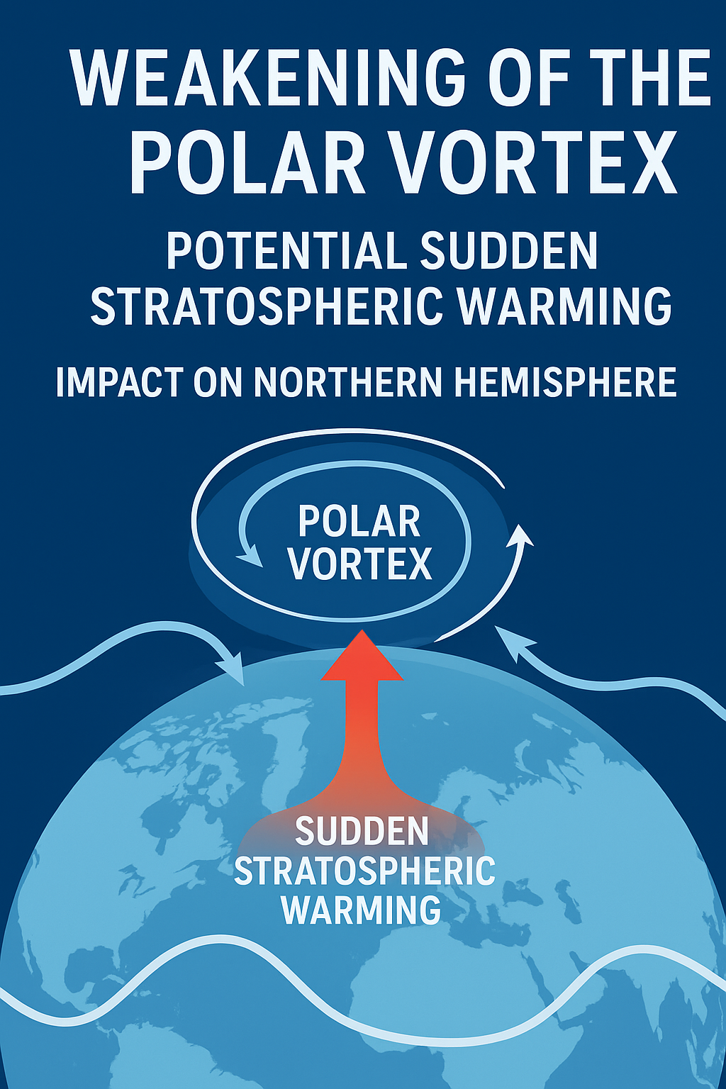
Every winter, far above our heads in the stratosphere, a powerful atmospheric engine spins: the polar vortex. This vast circulation of bitterly cold air, normally locked above the Arctic by strong westerly winds, guides the behaviour of the jet stream and exerts a surprisingly strong influence on our weather here at the surface. Most winters it goes largely unnoticed. But sometimes—perhaps every two or three years—the vortex wobbles, slows, or even collapses entirely. When this happens, we often witness dramatic changes in the weather across the Northern Hemisphere.
Currently, meteorologists are watching a weakening of the polar vortex that could evolve into a Sudden Stratospheric Warming (SSW) event. While SSWs are not guaranteed to produce extreme weather, they greatly increase the odds of unusual conditions, from severe cold spells to heavy snowfall or persistent wet periods.
In this article, we'll take a look at what an SSW is, how the current situation is developing, why it matters for weather patterns, and what the probabilities are of extreme weather. We'll also look at some key examples from past events to illustrate how powerful these stratospheric disruptions can be.
What Is a Sudden Stratospheric Warming?
A Sudden Stratospheric Warming is exactly what it sounds like: temperatures in the polar stratosphere, roughly 10–50 km above the surface, rise dramatically—sometimes by as much as 50°C in just a few days. This warming is not driven by the sun but by dynamic changes lower in the atmosphere.
When large atmospheric waves—generated by mountain ranges, land–sea contrasts, and strong winter weather systems—propagate upward, they can disrupt the normally stable circulation around the Arctic. If the disruption is strong enough, it slows, displaces, or even reverses the winds that make up the polar vortex.
There are two main types of SSW:
- Displacement events, where the cold core of the vortex moves away from the pole.
- Split events, where the vortex fractures into two or more smaller vortices. Split events typically cause the most impact on our weather.
An SSW is officially declared when the mean zonal winds at 60°N reverse from westerly to easterly. But the real interest for meteorologists lies in what happens after the reversal—because a disrupted stratosphere often leads to a disrupted troposphere, where our day-to-day weather happens.
Why Are We Seeing a Weakening Vortex Now?
During mid-winter, the polar vortex is normally at its strongest, as long polar nights reinforce the cold pool of air above the Arctic. But strong planetary waves, often generated by patterns such as a negative Pacific–North American pattern (PNA) or amplified low-pressure systems in the North Pacific, can inject energy upwards and disturb the vortex.
Currently, we’re observing:
- Increasing wave activity being forced upward from the troposphere.
- Significant warming signals over the Eurasian side of the Arctic.
- A weakening of the stratospheric zonal winds.
- Model projections that show a realistic pathway toward a major SSW.
It is important to stress that an SSW is not guaranteed—but the dynamical setup is present, and forecast models are flagging it as a very plausible outcome.
How an SSW Influences Surface Weather
An SSW does not immediately change the weather on the ground. Instead, it initiates a top-down cascade that usually unfolds over several days to several weeks:
- The stratospheric vortex slows or collapses.
- The disruption propagates downward into the mid-stratosphere.
- Eventually it reaches the lower stratosphere and upper troposphere.
- The jet stream weakens or becomes buckled.
- Weather patterns at the surface shift, often toward blocked configurations.
Blocked patterns are the key to extreme weather. When the jet stream weakens, high-pressure systems can become stationary, or “blocked”, causing prolonged cold, snow, or stormy conditions depending on where the block sits.
Historically, around two-thirds to three-quarters of major SSWs have led to significant cold spells across parts of Europe and North America. But not every region is equally affected, and some years see only subtle impacts.
What Might Happen This Time? Probabilities and Scenarios
While no two SSWs are identical, we can look at probabilities based on historical analogues and atmospheric modelling.
If the current vortex weakening evolves into a full SSW:
- 50–70% chance of a negative Arctic Oscillation (AO) pattern developing.
- 40–60% chance of colder-than-average conditions affecting parts of Europe.
- 30–50% chance of cold spells affecting eastern North America.
- 70–80% chance of noticeable jet-stream disruption, likely leading to:
- Increased blocking over Greenland or Scandinavia.
- Heightened risk of snowfall for mid-latitude regions.
- Amplified temperature contrasts (cold in some areas, unusually mild in others).
If the weakening stops short of an SSW:
Even without a full SSW, a weakened vortex can still affect the weather:
- Greater weather volatility.
- Short-lived cold episodes.
- More meridional (north–south) jet-stream flow.
- Increased likelihood of heavy precipitation events.
In short: significant impacts are possible, but surface outcomes depend heavily on the final structure of the stratospheric disruption.
Looking Back: What Past SSWs Can Teach Us
Studying prior events helps us understand the range of possible outcomes.
2009 – The Classic Split Event
One of the most dramatic SSWs in recent memory occurred in early 2009. The polar vortex split into two vortices, and the effects were felt across Europe. The UK experienced a prolonged cold spell with widespread snowfall—one of the snowiest winters of the 21st century up to that point.
2013 – Bitter Cold and Blocking
The January 2013 SSW produced long-lasting impacts. Europe and North America both saw persistent cold, with the UK enduring a cold March—one of the coldest in over 50 years. This event is a good example of how long-lasting surface effects can be when downward propagation is strong.
2018 – “The Beast from the East”
Perhaps the most famous modern SSW, this late-February event caused a dramatic split of the vortex. As the disturbance propagated downward, the jet stream weakened and shifted south, opening the door for frigid Siberian air to sweep into Europe.
For the UK, this resulted in the infamous Beast from the East, bringing blizzards, disruptive snowfall, and record low temperatures. Many parts of Europe and North America felt the effects for weeks.
2019 – A Mild Outcome Despite a Major SSW
It’s important to remember that an SSW does not guarantee extreme weather. In early 2019, despite a technically major SSW, the downward propagation into the troposphere was weak. Europe saw very few impacts, and parts of the continent were notably mild.
This is a reminder that every SSW is unique.
Why Some SSWs Affect the Surface—and Some Don’t
Several factors determine whether an SSW reaches the surface:
- Strength of wave forcing: Stronger forcing typically produces a deeper “downward signal”.
- Location of warming: Eurasian-centric warmings often favour impacts on Europe.
- Whether the vortex splits or displaces: Splits are more likely to produce cold outbreaks.
- Background state of the atmosphere: Including the ENSO phase, North Atlantic SST patterns, and snow cover patterns across Siberia.
Even in the presence of a major SSW, surface weather is still modulated by tropospheric drivers such as the Madden–Julian Oscillation (MJO) and the interplay of the North Atlantic and Pacific jet streams.
The Current Signals: How Concerned Should We Be?
At present, the atmosphere shows many of the precursors associated with impactful SSW events:
- Enhanced upward wave activity.
- Slowing vortex winds.
- Significant warming developing over the polar stratosphere.
- Atmospheric coupling potential within forecast range.
But there are also uncertainties, particularly around whether:
- The vortex will fully reverse (the threshold for a major SSW).
- Any resulting SSW will be a split or displacement event.
- Downward propagation will be strong enough to influence the troposphere.
Meteorologists often describe this as a “loaded atmosphere”: the potential for impactful winter weather is elevated, but we are waiting for confirmation about the eventual outcome.
What Regions Should Watch Closely?
Europe
Europe is often the region most affected by SSW-driven blocking. If the upcoming event becomes a split vortex, the risk of prolonged cold increases substantially, particularly for northern and western Europe. Heavy snowfall becomes more likely, especially where Atlantic moisture meets continental cold.
United Kingdom
The UK sits at the crossroads of Atlantic and continental air masses, making it highly sensitive to stratospheric disruptions. Should a Scandinavian or Greenland block develop, the UK could experience:
- Substantial cold spells
- Increased snowfall risk
- Lower-than-average temperatures lasting multiple weeks
But, as always, the opposite—mild and stormy conditions—remains possible if blocking sets up elsewhere.
North America
The eastern US and Canada are the regions most likely to be affected. A weakened jet stream increases the odds of Arctic air surges, though timing and intensity depend on the placement of the stratospheric anomalies.
Final Thoughts: A Period of Elevated Risk, Not Certainty
The current weakening of the polar vortex is a reminder of how interconnected our atmosphere is. What happens 30 km above the Arctic has the power to reshape weather patterns across half the globe.
While it is too early to declare with certainty that a major SSW will occur—or to predict its exact impacts—the signals are strong enough that meteorologists, forecasters, and weather enthusiasts should pay close attention over the coming weeks.
The probabilities tell a clear story: the chances of unusual winter weather in the Northern Hemisphere are higher than normal, especially if the vortex continues to weaken. But probabilities are not guarantees. We are dealing with a complex, chaotic system where small changes at high altitudes can have very different results on the ground.
What we can say with confidence is this:
The atmosphere is primed, the polar vortex is vulnerable, and the next few weeks will be crucial in determining how winter unfolds.